-
Apks Mods
-
Maps and Navigation
-
Soviet Military Maps Free
Soviet Military Maps Free is a Maps and Navigation App for Android developed by ATLOGIS Geoinformatics GmbH & Co. KG.
Download the latest version (6.3.0 free) of the apk here, in Apks Mods released February 27, 2021
Soviet Military Maps Free mod (unlocked) has been downloaded 1,000,000+ since February 27, 2021. Is Free and the file size is 8.22 MB. does not offer in app purchases, users rated it with 4.2/5 stars with over 24109 ratings.
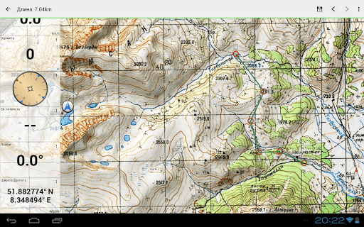
World-wide topographic maps.
Offroad Navigation App with worldwide topographic maps (mainly Russian General Staff). For many countries in Africa and Asia these maps still belong to the best available topomaps.
Available map layers:
• Topomaps worldwide (worldwide seamless coverage, mainly 1:100.000)
• ROSREESTR The Federal Service for State Registration, Cadastre and Cartography
• Google Maps (Satellite images, Road- and Terrain-Map)
• Open Street Maps (OSM Mapnik, Osmarender and Cloudemade Cyclemap)
• Bing Maps
• ESRI Maps
This app gives you similar mapping options as you might know from Garmin or Magellan GPS handhelds.
Main features for Outdoor-Navigation:
• Create and edit Waypoints
• GoTo-Waypoint-Navigation
• Track Recording (with speed and elevation profile)
• Tripmaster with fields for odometer, average speed, bearing, elevation, etc.
• GPX,KML - Import
• Search (placenames, POIs, streets)
• Customizable datafields in Map View and Tripmaster (e.g. Speed, Distance, Compass, ...)
• Bulk-download of map tiles for OFFLINE USAGE (NOT in free version)
• Импорт Oziexplorer map format in OZF2 OZFX3 extension (NOT in free version)
• Импорт OpenStreetMaps in vector format (NOT in free version)
• Waypoint-/Track-Sharing (via eMail, Facebook, ..)
• and many more ...
Soviet Military Maps is the perfect moving map app for offroad trips, adventure travels and expeditions. You are planning cross country trips to Sahara desert or a trekking tour to the Himalayas ? With the Russian topos you have always a great alternative to other map sources. Beneath the good topography the maps include many small trails and unpaved roads that are missing in other map sets.
The Russian maps have additional English labels.
Attention: The Soviet Military Maps were created mainly in the 80ies and are less interesting for industrialized countries. Outside Africa and Asia you'll find the OSM / Google map layers more useful.
Please note: This app does not provide direct "Turn-by-Turn" navigation - but with a selected waypoint you can easily switch to Google Navigation.
LIMITATIONS OF THE FREE VERSION:
• Ads
• Max. 3 Waypoints
• Max. 3 Tracks
• No import of waypoints and tracks
• No Bulkdownload
• No Local City DB (Offline Search)
• No Hillshading Overlay
Please contact us if you have any questions, feature requests or bug reports regarding this app:
[email protected]Map coverage:
Scale 1:100.000 and 1:200.000 :
Europe, Afghanistan, Azerbaijan, Georgia, Japan, Jordan, Latvia, Lithuania, Kazakhstan, Kyrgyzstan, Morocco, Mongolia, Pakistan, Russia, Syria, Tajikistan, Turkey, Turkmenistan, Ukraine, Uzbekistan, Belarus
Scale 1:200.000 :
Afghanistan, Egypt, Algeria, Angola, Argentina, Armenia, Azerbaijan, Bahrain, Bangladesh, Belarus, Benin, Bhutan, Bolivia, Botswana, British Virgin Islands, Bulgaria, Burkina Faso, Burma, Cambodia, Cameroon, Central African Republic, Chad, Chile, China, Comoros, Ivory Coast, Cuba, Cyprus, Czech Republic, DR Congo (part), Djibouti, Eritrea, Estonia, Ethiopia, Falkland Islands, Finland, Gambia, Georgia, Ghana, Guinea, Guinea-Bissau, Iceland, India, Indonesia, Iran, Iraq, Israel, Jamaica, Jordan, Kazakhstan, Kenya (part), Kuwait, Kyrgyzstan, Laos, Latvia, Lebanon, Lesotho, Liberia, Libya, Lithuania, Madagascar, Malawi, Malaysia, Mali, Mauritania, Moldova, Mongolia , Morocco, Mozambique, Namibia, Nepal, Niger, Nigeria, North Korea, Oman, Pakistan, Philippines, Qatar, Romania, Russia, Saudi Arabia, Senegal, Sierra Leone, Singapore, Slovakia, Somalia, South Africa, South Korea, Spain, Sri Lanka , Sudan, Svalbard, Swaziland, Sweden, Syria, Taiwan, Tajikistan, Tanzania (part), Thailand, The Gambia, Togo, Tunisia, Turkey, Turkmenistan, Ukraine, United Arab Emirates, Uzbekistan, Vietnam, Western Sahara, Yemen, Zambia, Zimbabwe
Scale 1:250.000 (Local maps from USGS, Geoscience Australia, CTIO ):
USA, Canada, Australia
Scale 1:500.000:
All other countries
More Maps and Navigation Application
★★POWERFUL★★
★★EASY TO USE★★
★★MOST ACCURATE★★
GPS Speedometer
"The single best app for finding your way in the city"
The New York Times
Earn more by executing orders of different taxi companies in one application.
The simple and beautiful way to get around. 200+ cities across the globe.
Car GPS with driving directions, live traffic, speed radar & Offline USA map
Real-Time Transit: bus times, train times, subway maps, live directions & alerts
Avenza Maps is a powerful offline map viewer with a connected in-app Map Store
GPS for marine, hiking, off road, trail navigation. FREE offline maps and charts
Ride via taxi affordably, quickly and safely
Off-road GPS navigator with offline maps support, compass and track recording.
Navmii - crowd-powered GPS navigation with offline maps, traffic (Navfree)
Find Driving Directions using GPS, Maps, Voice Navigation & Directions App