Maverick: GPS Navigation screenshot 1Maverick: GPS Navigation screenshot 2Maverick: GPS Navigation screenshot 3Maverick: GPS Navigation screenshot 4Maverick: GPS Navigation screenshot 5Maverick: GPS Navigation screenshot 6Maverick: GPS Navigation screenshot 7

Maverick: GPS Navigation apk + mod + data for android

Maverick: GPS Navigation is a Maps and Navigation App for Android developed by Code Sector. Download the latest version (2.8) of the apk here, in Apks Mods released February 27, 2021

Maverick: GPS Navigation apk + mod + data has been downloaded 5,000,000+ since February 27, 2021. Is Free and the file size is 26.24 MB. does not offer in app purchases, users rated it with 4.5/5 stars with over 27026 ratings.

Off-road GPS navigator with offline maps support, compass and track recording.

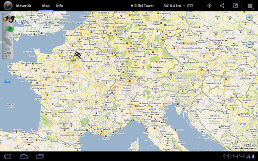
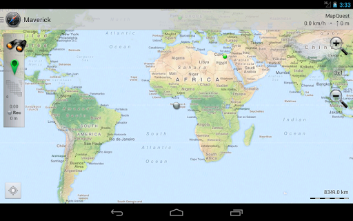
Use offline maps and GPS even without an internet connection. This app is great for hiking, boating, geocaching and other outdoor activities.

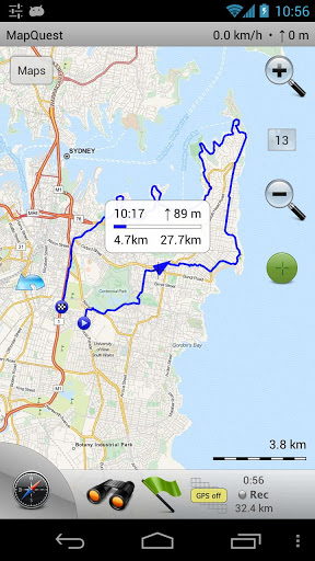
• Multiple global and regional online maps, including: Bing, Yandex, Open Street Maps, OSM Cycle, OSM Public Transport, Multimap (UK), OutdoorActive (Germany, Austria, South Tyrol), Cykloatlas, HikeBikeMap (Germany), Open Piste Map, NearMap (Australia) and many other maps.

All maps automatically cached for offline use. Use Mobile Atlas Creator to download maps or MAPC2MAPC to convert maps from other formats.

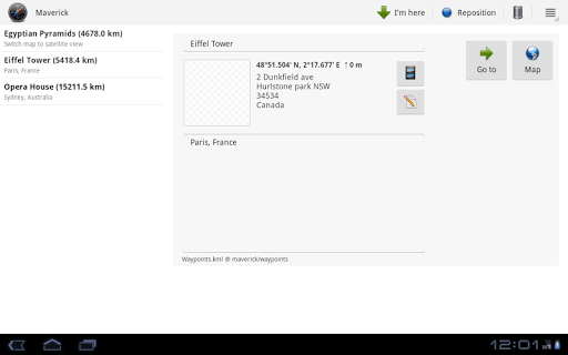
• Share your current or planned position
You can send address, GPS coordinates, link to Google Maps and even map image.

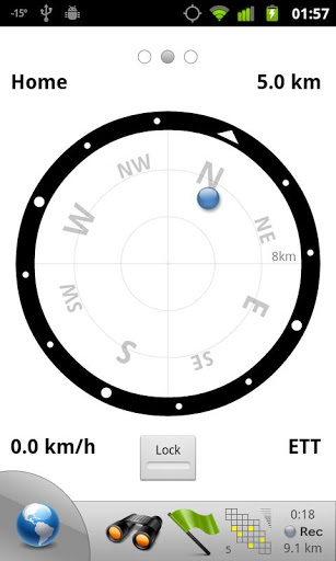
• Navigate easily
Build-in radar shows the direction, distance and estimated time to a point of interest.

• Save places you visit
All waypoint stored in KML file and can be viewed and edited in Google Earth.

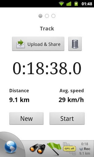
• Record tracks with single tap
Tracks are recorded in GPX format and can be viewed in Google Earth and other software.

• Upload tracks to GPSies
Free account is required for uploading.

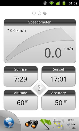
• Trip Computer
Watch speed, altitude, pitch and many other values.

Only in Pro version:

• Unlimited waypoints and tracks
• Lock compass to bearing
• UTM and OSGB grids
• OS Explorer maps
• FourSquare support

We can implement standard Google MapView, but it's limited - no caching and terrain view. If you need it, please email us or leave a comment.

More Maps and Navigation Application
GPS Speedometer and Odometer
★★POWERFUL★★

★★EASY TO USE★★

★★MOST ACCURATE★★

GPS Speedometer
Citymapper - Transit Navigation
"The single best app for finding your way in the city"
The New York Times
Taxsee Driver
Earn more by executing orders of different taxi companies in one application.
Transit  • Bus & Subway Times
The simple and beautiful way to get around. 200+ cities across the globe.
GPS Navigation System, Traffic & Maps by Karta
Car GPS with driving directions, live traffic, speed radar & Offline USA map
Moovit: Timing & Navigation for all Transit Types
Real-Time Transit: bus times, train times, subway maps, live directions & alerts
Avenza Maps - Offline Mapping
Avenza Maps is a powerful offline map viewer with a connected in-app Map Store
Polaris GPS Navigation: Hiking, Marine, Offroad
GPS for marine, hiking, off road, trail navigation. FREE offline maps and charts
Navmii GPS World (Navfree)
Navmii - crowd-powered GPS navigation with offline maps, traffic (Navfree)
Easy Taxi, a Cabify app
Ride via taxi affordably, quickly and safely
GPS, Maps, Voice Navigation & Directions
Find Driving Directions using GPS, Maps, Voice Navigation & Directions App
GPS Speedometer - Trip Meter - Odometer
Get GPS Speed with one of the best GPS Speedometer Apps. Auto GPS Trip Meter!
Detailed Information:

Maps and Navigation Android Application

Updated Size Installs
February 27, 2021 26.24 MB 5,000,000+
Version Rating Ads
4.0.3 and up Everyone Does not contain ads
Price In-App Purchase
Free No
Version Release Changes
2.8 Version 2.8

• 'What 3 words' support
• Bugfixes

Version 2.7.4

• New maps

Version 2.4:

• Address/places search.
• Using new Fused Location Provider.
• Support for tracks formats:
• GPX (routes)
• PLT (OziExplorer)
• KML (Google Earth)
• NMEA (Canon 6D, S100, etc)
• Pebble support.
• Segments in tracks.
• Better multi-touch.
• Google Street View.
• NearMap Australia (paid service).
• Use external SD card option in Settings.
Developer Category
Code Sector Maps and Navigation
Other Code Sector Apps
SpeedView: GPS Speedometer
Advanced speedometer application that offers lots of useful features.