-
Apks Mods
-
Maps and Navigation
-
Map Coordinates
Map Coordinates is a Maps and Navigation App for Android developed by Soft Stack Dev.
Download the latest version (5.2.5) of the apk here, in Apks Mods released September 3, 2022
Map Coordinates full apk has been downloaded 1,000,000+ since September 3, 2022. Is Free and the file size is 10.42 MB. Offers in app purchases, users rated it with 4.5/5 stars with over 22905 ratings.
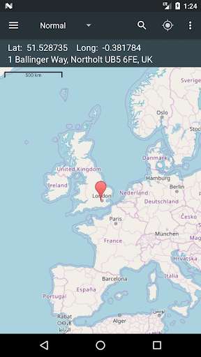
The easiest way to find coordinates on the map!
A single tap on the map gives you access to world coordinates. In addition, Map Coordinates offers a full set of tools like distance measurement, current GPS location, history / favorite locations, share location, find location or copy coordinates / address. You can switch between multiple coordinate types like decimal degrees, DMS (degrees, minutes and seconds) or even special types like what3words, MGRS, UTM or GEOREF.
The app is designed to easily determine the coordinates and address of a point on the map and share them with friends via SMS, email or social apps.
When you need to find a location, you can either type / paste the address / coordinates in a search field or enter each coordinate value one by one in it’s own field using the advanced search options. what3words, MGRS, UTM or GEOREF can be searched for only by using the single search field.
The current GPS location is best received while the mobile device is located outdoors. The GPS satellites are easy to be found when there is no interference like buildings or clouds. Even if the device is located indoor, the location can be accurately found through WiFi network but only if the device is connected to that network.
The side drawer menu is used to navigate between different parts of the app like History / Favorites but it is also used to switch the map provider. The available map providers are Google Maps and Open Street Maps, each of them having different map types. Under Open Street Maps there is also a compass available all the time.
Settings can also be accessed from the side navigation drawer. There you have the options to switch between existing coordinates types, change the visibility of the address bar or you can enable the Distance measure tool and the Elevation tool. Elevation displays the altitude of the selected location on the map.
Notes:
1. GPX and KML file types are supported with certain limits: Only simple waypoints are processed for GPX files and only Placemarks are processed for KML files.
2. UTM, MGRS and GEOREF coordinates types are available as paid options
We hope that this app fulfills your needs but if you have any other expectations, please don’t hesitate to contact us and we will try to help you out.
MOD Features
MGRS coordinates
type unlocked;
UMT coordinates
type unlocked;
Remove Ads unlocked;
Measurement Tools unlocked;
Disabled / Removed unwanted Permissions + Receivers + Providers + Services;
Optimized and zipaligned graphics and cleaned resources for fast load;
Ads Permissions / Services / Providers removed from Android.manifest;
Ads links removed and invokes methods nullified;
Ads layouts visibility disabled;
Google Maps Location works;
Google Play Store install package check disabled;
Debug code removed;
Remove default .source tags name of the corresponding java files;
Analytics / Crashlytics / Firebase disabled;
No active trackers or advertisements;
Languages: Full Multi Languages;
CPUs: armeabi-v7a, arm64-v8a;
Screen DPIs: 120dpi, 160dpi, 240dpi, 320dpi, 480dpi, 640dpi;
Original package signature changed.
More Maps and Navigation Application
★★POWERFUL★★
★★EASY TO USE★★
★★MOST ACCURATE★★
GPS Speedometer
"The single best app for finding your way in the city"
The New York Times
Earn more by executing orders of different taxi companies in one application.
The simple and beautiful way to get around. 200+ cities across the globe.
Car GPS with driving directions, live traffic, speed radar & Offline USA map
Real-Time Transit: bus times, train times, subway maps, live directions & alerts
Avenza Maps is a powerful offline map viewer with a connected in-app Map Store
GPS for marine, hiking, off road, trail navigation. FREE offline maps and charts
Ride via taxi affordably, quickly and safely
Off-road GPS navigator with offline maps support, compass and track recording.
Navmii - crowd-powered GPS navigation with offline maps, traffic (Navfree)
Find Driving Directions using GPS, Maps, Voice Navigation & Directions App
Detailed Information:
Maps and Navigation Android Application
| Updated |
Size |
Installs |
| September 3, 2022 |
10.42 MB |
1,000,000+ |
| Version |
Rating |
Ads |
| 4.4 and up |
Everyone (Users Interact) |
Contains ads |
| Price |
In-App Purchase |
| Free |
Yes |
| Version Release |
Changes |
| 5.2.5 |
- Fixed Free 24/h buttons in Shop
- Show elevation as 0m on sea
- Other small fixes and improvements |